


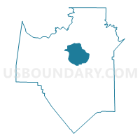
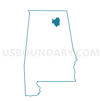
Henryvill Methodist Church, Marshall County, Alabama
About
Outline

Summary
| Unique Area Identifier | 522500 |
| Name | Henryvill Methodist Church |
| County | Marshall County |
| State | Alabama |
| Area (square miles) | 25.24 |
| Land Area (square miles) | 15.84 |
| Water Area (square miles) | 9.39 |
| % of Land Area | 62.78 |
| % of Water Area | 37.22 |
| Latitude of the Internal Point | 34.41541360 |
| Longtitude of the Internal Point | -86.28681870 |
Maps

Graphs
Select a template below for downloading or customizing gragh for Henryvill Methodist Church, Marshall County, Alabama


Neighbors
Neighoring Voting District (by Name) Neighboring Voting District on the Map
- Bucksnort Comm Ctr, Marshall County, AL
- Guntersville Rec Center, Marshall County, AL
- Guntersville Rec Center, Marshall County, AL
- Guntersville Rec Center, Marshall County, AL
- Hebron Rec Center, Marshall County, AL
- Prospect Cemetery, Marshall County, AL
- Warrenton Comm Center, Marshall County, AL
Top 10 Neighboring County Subdivision (by Population) Neighboring County Subdivision on the Map
- Guntersville CCD, Marshall County, AL (14,258)
- Grant CCD, Marshall County, AL (10,201)
- Union Grove CCD, Marshall County, AL (6,430)
Top 10 Neighboring Place (by Population) Neighboring Place on the Map
Top 10 Neighboring Unified School District (by Population) Neighboring Unified School District on the Map
Top 10 Neighboring State Legislative District Lower Chamber (by Population) Neighboring State Legislative District Lower Chamber on the Map
Top 10 Neighboring State Legislative District Upper Chamber (by Population) Neighboring State Legislative District Upper Chamber on the Map
Top 10 Neighboring 111th Congressional District (by Population) Neighboring 111th Congressional District on the Map
Top 10 Neighboring Census Tract (by Population) Neighboring Census Tract on the Map
- Census Tract 303, Marshall County, AL (6,430)
- Census Tract 302.01, Marshall County, AL (5,381)
- Census Tract 302.02, Marshall County, AL (4,820)
- Census Tract 307.02, Marshall County, AL (4,024)